Which Well Are They Killing?

by BK Lim, Geohazards Specialist (1 Sept 2010, hydrocomgeo@gmail.com).

Some of the most critical details of the disastrous Deepwater Horizon (DWH) blowout on 20 April 2010 were never made public. We are told that only one well location was drilled when in fact BP drilled at 3 wells at 3 different seabed locations.

In fact the 20 April blowout was the last of several serious near-misses and the blowout location was actually 714ft north of Well A location. Despite its importance, there were no public media reports of a second underground explosion 2 days after the initial blowout on 20 April 2010 burst into flames onboard the Deepwater Horizon.

Four and a half months is a very long time to permanently kill what was initially reported as a “small leak in a very big ocean”. We were first told that it would take 3 months to drill the two relief wells (C and D)? We were told that the Relief wells were the surest way to kill the wild gushing well. Well, mid-August had come and gone by without the promised
permanent kill by the Relief wells.

Months had been spent discussing all the intricate details of killing the zombie well in so many ways, from Top Kill to Bottom Kill to Static Kill to Relief Kill that it was almost killing me instead of the zombie well. Has it occurred to them, the zombie Well A could not be killed because it was the wrong well?

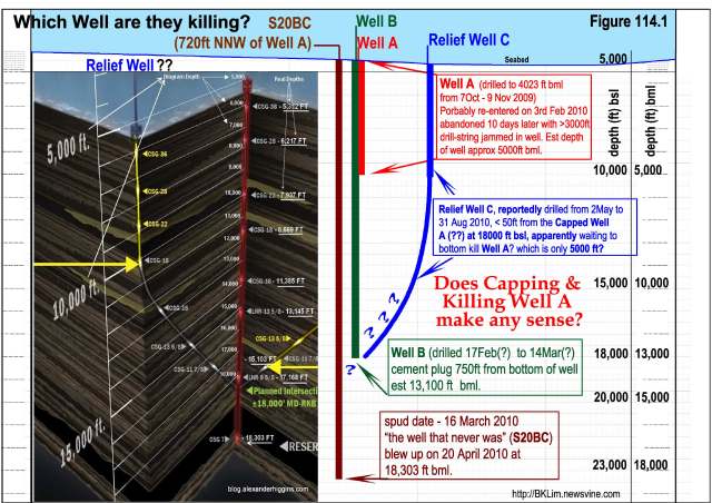
What if the capped Well A was drilled only to slightly over 5000ft bml? It would easily explain why Well A could only be cemented to 5000ft. It could explain how 40% of the 500 barrels of cement went into the formation. It could explain why only 3000 ft of drilling rod was in the well and not 18,000ft. It could explain why Well A had to be abandoned on 13th Feb due to 3000ft of drilling rod reportedly jammed at the bottom of Well A. It could explain the mystery of BP’s attempts to kill the zombie well that refused to lay dead.

See figure 114.1 on the depths of the 3 wells drilled in correct perspective.

Posted in Uncategorized | Tagged | 1 Comment

More Mystery Shrouds the Blown Well at the Macondo Prospect

The mystery of the 20th April Blowout revealed – Answers to questions Raised 001.

by BK Lim, Geohazards Specialist (18 August 2010, hydrocomgeo@gmail.com).

Every questions posted on my newsvine-blog had been answered as accurately as possible. However, I cannot track and answer questions posted on other blogs. Short and quick answers to questions on a complicated matter such as a blowout do no justice and can be easily misconstrued. This article is specially written to address some of the serious questions posted on other blogs that had recently been brought to my attention and posted on my blog on 18 Aug 2010. As can be seen, the answers to each short question are actually quite long.

In any developing disaster situation, many technical details had to be intentionally left out until they can be verified. Like any responsible blogger-citizen, I spent a lot of time in seeking, checking and analyzing facts and data before arriving at the conclusion. Even in the “rush-rush” oil industry, 2 to 3 weeks is the normal time-frame in coming out with an assessment report. Predictive Truth reporting is 10 folds harder than factual reporting. There must be consideration for facts deliberately hidden from public view and information that had been unintentionally or intentionally distorted to mislead. I had been severely criticized and widely condemned for being late in answering my critics; as you can see below:

Pity you didn’t take your own advice.

The points raised in my post above are a catalog of what I can only assume are errors, as you have failed to address them. I will not be asking Mr. Berman to elaborate on anything, as I think you have just discredited yourself beyond redemption and checkmated yourself.
Comments made by FintanDunne at #9 Aug 19 2010.

Many questions cannot be answered in isolation without being ripped apart by the waiting pride of lions. Many sensitive revelations cannot be revealed before the time is ripe, in this chess game of “hide and seek” and “catch me if you can” multi-billion cover-up scandal that is slowly being unraveled. Time is on the side of truth and it is the detractors’ strategy to push the truth seekers to their untimely death (sorry pun intended). They have the funding and wide array of machinations to seek and destroy all those that stood up like a “sore thumb” in their quest to dupe the unsuspecting world. In the battle of David Vs Goliath, it has been shown time and time again David’s crowd of encouragement will quickly dissipate at the first onslaught and massive show of force by Goliath. That is the strategy Goliath is embarking on. The only weapon the minority truth-seekers have is the little “logic truth-seeking” knife to cut the soft underbelly of the giant mammoth. A simple but nevertheless, still a potent Giant Killing weapon if only one is brave enough to get within striking distance. Our quest for the truth will be lost, if we all lose faith in our conviction at the first sign of trouble.

We cannot stop and turn back now when we are getting so close to the truth. (bloggers like Freebirdreaming and Kokohito will see to that). The incessant attacks on my credibility are first real signs we have stumbled on the truth that had been so well hidden under tons of BP’s paid PR bullshits and BP’s funded Oilmen Experts’ opinions and comments.
freebirdreaming
BK……….. it more then ‘that’s all we can do’, and it pisses me off when you talk like that.
now……. do what you do! you do it so well.
8!#2.2 – Wed Aug 18, 2010 3:09 AM HKT
kokohito
BK Lim
initial influx that caused the blowout was from the extended gas charged pressure (EGCP) zone and not from the bottom of the well as most had thought so
Read your articles again except that this time we appreciate the severity of the problem that GWSF represented.
BP must extract the oil NOW. Stop the carnage. To those people who still choose to cohort with BP in this massive cover-up is just abominable!
We are now in a ‘war’ where good is fighting evil on a massive scale. May all the good people rise to the challenge now and fight we must to win this ‘war’. Enough is enough!
It is like fixing a giant jigsaw puzzle.
Thank you very much for your herculian effort.
Yes, I am voting you up.
6!#15 – Fri Aug 20, 2010 2:56 AM HKT

Like a giant jigsaw puzzle, it is important to have a general framework and not be too obsessed with fine details as otherwise we would miss the forest for the trees. If the framework is correct, the missing pieces will fall in place as new evidence or facts are verified. Many investigations in the past had gone off-tangent due to inaccurate facts or lack of data. To keep the articles short some technical details unfortunately had to be left out; for later postings. Still I could not resist the temptation of “letting the cat out of the bag” in addressing the genuine queries from ardent supporters. Bits and pieces of the answers “urgently pressed for by my detractors” can be found in the numerous lengthy comments not only in my blog but in so many articles I had commented on. I had personally lost track and so the phrase “my answers can actually be found hidden in my previous articles and comments” should be taken in good faith and not misconstrued as being sinister with the intention of “Now I find that either you are wriggling out of errors or claiming to be playing silly mind games”. Should I be denied the justice of answering the questions first before being condemned? In several emails in early August, I apologised to many for my delayed responses to their queries due to the grief and shock of the passing of an immediate member of the family. I am sure all human beings can sympathise with that.

Diagrammatic illustrations are time consuming. Some inconsequential errors and omissions that do not really matter in the larger scale of scheme were reluctantly left uncorrected due to time constraints. Crucial mistakes that could make the difference in the interpretation of the blowout were however tackled as soon as they were discovered. The objective of such an approach is to ensure there is no 180º reversal in the journey towards revealing the truth.

1. Surface location of DWH and well location that blew 20th April 2010.

Ballastic Analysis of DWH & Riser Wrecks
“It is therefore intriguing that Well A should be more than 520ft SSE of DWH’s surface location.”
Question: #8 (1)
Have you compared your figure of 520ft NNW of Well A with the official position of the DWH rig? Is it different than the official position, or is the official position of DWH in NOAA, or Congressional reports assumed to be the position of well A? It’s one of the strongest points you make yet you only assert it without laying any foundation.

The fact that BP would drill at an unreported location in obvious violation of mandatory reporting to MMS, means that the official well location would still be Well A. If BP were to report it was drilling the second well at a different location (other than the approved Well B location) BP would have to notify and submit a new Exploration Plan to MMS. That would mean more expensive delays since BP cannot off charter DWH while waiting for approval.

Inaccurate reporting is also evident in BP’s well activity reports. Alex Higgins in his excellent detective work (Suspicious BP-well-activity-reports) noted several discrepancies, including the change in the well-bore number from 00 to 01 and ByPass no: from 00 to 01 for the week 3/14/2010-3/20/2010. There were 2 Well Activity reports for the same period with conflicting information (report nos: 150694 and 150699). For example in the item Last BOP test on 3/15/2010, the high pressure was 6500psi while in the earlier report for the same test the high pressure was 10,000psi. The 2 conflicting reports also reported contradicting well-bore and bypass numbers.

Why did BP choose not to drill at Well B location as the second well?
(Answer given in #4 of DWH Blowout CSI)
Most oil companies would apply for a backup location (in this case Well B) close by since they were unsure whether it would even be drilled. At 300ft apart (between well A and B), even a layman from outside the oil industry would see that it is ridiculously near especially when the water depth is 5000 ft (6% of WD) and the reservoir target is another 18000ft below seabed (1.3% of total drill depth). No for all purposes and intent, Well B location is for “show only”; location wise but it has other purposes.

A second well would be useful in case of unexpected delay and as a backup location. As in BP’s case, the permit for well A and B was valid for the period; 15 April-24 July 2009 and from 15 April till 24 July 2010 (100 days each) respectively. Actual drilling of each well normally takes between 2 to 4 weeks with another 2 to 3 weeks for testing the well. The period / time of exploration is more important than the location since MMS can keep track of the days spent at location but not the precise well location. Even then BP did not drill the wells within the allocated exploration time frame as permitted in BP’s Application to MMS, Control no: N-9349 dated 10 March 2009. Well A was drilled by Marianas from 7 Oct till 9 Nov 2009 and by DWH “officially” from 6 Feb till 20 April 2010. This is proof that actual field operations do not strictly follow proposed plans in the approved MMS permit.

Obviously with the number of serious out-of-control well problems BP was having at Well A, it would be suicidal and outright Dumb if not Criminal to drill at well B which was so close to Well A (only 300ft). BP might have also realised that Well A and Well B lie too close to a shallow NE-SW fault. Video clips of oil-gas gushes at points along this fault line can be seen on the You-tube website. Figure F1 showed just 2 ROV locations on 10 June and 25 May 2010. This also precisely the same reason why BP could not have sidetracked or bypassed from Well A. To do so would have been willful negligence. Was there a thorough investigation on the drilling problems at Well A before proceeding to the second well as required by International Safety Policies.

BP arrogantly thought that by moving approximately 750ft NNW perpendicularly to the fault-line, they had minimized the blowout risk. Whether BP had diligently analysed the geohazards risks or had acted negligently with an arbitrary offset from the problematic Well A, is open to question. Being an experienced technological giant, BP should have known that it is not a matter of distance and direction. There are enough documented past disasters that had resulted from such hasty and arbitrary shifting of well location without a proper and diligent geohazards assessment. It is also a question of legitimate insurance coverage since each well location must be accompanied by a drilling risk report just as Well A and Well B must have had one each. It is also strange that BP had not transferred responsibility and liability to the geohazards expert’s drilling risk assessment on the two wells drilled, as it is becoming more and more obvious that a simple well blowout could not have been so disastrous. Even by looking at the bathymetry, it is obvious that there had been negligence in the charting and assessment of the geohazards. See more elaborate discussions in Would-a-better-bathymetry-chart-have-made-the-difference?

Out of plain ignorance, incompetence or arrogance, shifting the second well 750ft NNW of Well A, had only increased the drilling risk by moving it closer to the source of the geohazards problem. See the discussions on Misinterpretation on Seabed Escarpment below:
Man of Knowledge
Have you seen this document?

Click to access 29977.pdf

It describes conclusions of a shallow hazards assessment (page 10) and indicates the escarpment is a “sea floor expression of a deeply buried scarp associated with mass wasting.”
I would be interested in your comments on this.
5!#29 – Thu Aug 5, 2010 4:40 AM HKT

BK Lim
The full paragraph is as follows:
The seafloor at the proposed “A” location is in a water depth of 4992 ft and dips to the south-east at ~3.0º. The only seafloor feature identified on the exploration 3D seismic data within the vicinity is a low-relief escarpment approximately 1,000 ft to the south of the “A” location which is the seafloor expression of a deeply buried scarp associated with mass-wasting.
If you read carefully, the escarpment was identified in the exploration 3D seismic data, not any of the geohazards site survey data. Isn’t that funny? That by itself should ring several alarm bells. ~ 3º is mighty steep in seabed bathymetry.
1. It means that the geohazards site survey did not pick up the escarpment even though it was identifiable in the broader exploration 3D seismic data and satellite images. So what was wrong with the geohazards site survey whose primary objective was to identify and analyse structural features like this? Why was the 3D seismic doing the work of the High resolution Site survey?
2. Exploration and geohazards experts have totally different perspective. Geohazards Geophysics focuses from seabed to about a thousand metres (Max). The report says – low relief escarpment, 1,000ft south of loc A. In my article on whether “a better bathymetry interpretation could have made the difference?” location A and B were smack on the top edge of the escarpment. If you look at the satellite image, you cannot miss the whole escarpment. The total drop in height is about 150-175ft. The 3-D seismic data (being designed to image thousands of metres below) cannot see clearly at seabed level (an effect we call smearing). Why spend more than a million bucks to run a site survey specifically designed to pick up such details, only to ignore it and use 3D seismic to detect the “low relief” without even an estimate of the height? It is like using the jack hammer to drill a pin-hole.

It also reminds me many years ago where one enthusiastic exploration geo who thought that his 3D exploration seismic could identify the geohazards better and ended up with a blowout. Another one tried and picked multiples as his hazards anomalies. As I said before, each type of data has its own use and none is superior over the other.

3. Being exploration experts they probably did not see the significance of the escarpment and probably did not understand the deep meaning of the words used “deeply buried scarp associated with mass wasting”. Deep means they understood that there was a deeper extension to the feature observed on the seafloor. It means that it is not a superficial structure with no “roots”. Mass wasting – (I don’t normally like to use this term) basically means “wasting” like in deterioration, weathering or breaking down. So combined with the word mass – the whole description simply means an unconformable structure extending deep below the seafloor. Now doesn’t this fit the description of my model – a fractured (/weathered/disintegrated) dyke/salt dome/diaper or any vertical body?

So BP did actually notice the structure but did not realise how hazardous it was. Sounds familiar? Those who had commented and ridiculed my model as being “crap, comical and total nonsense” probably had the same misunderstanding or poor concept of geohazards assessment. The question being asked at this point is; Where were BP’s geohazards specialists? Was BP trying to save some money by using 3D seismic experts to map both the oil reservoir and geohazards as well?

Obviously the end result is as disastrous as the previous 3D-seismic experts’ attempts at geohazards assessment more than 20 years ago – a blowout.

Exploration and Geohazards Geophysics may share the same fundamentals but are worlds apart in specific objectives and techniques. Needless to say, there are many experts within the geohazards industry who are not even aware of the fundamental differences. We are sometimes our own worst enemies.
5!#29.2 – Fri Aug 6, 2010 9:32 AM HKT

Evidence BP drilled the 2nd well at S20BC location – refer to figure 3 (Forensic Analysis of DWH & Riser Wrecks)
1. The massive oil gush (largest of the reported 3 leaks along the fallen riser) at S20BC is close to Centre of debris circle (suspected surface location of DWH) – approx 120 ft NW, 2.5% of water depth (WD).
2. This is evidently an explosion crater with debris and continuing oil-gas gushing out of a sub-horizontal pipe that looks like a well-head casing. One video comment had estimated the diameter of the pipe to be 21 inches – same as well head casing(?). Though there is no scale to substantiate this comment, there are distinct differences with the damaged riser piping seen on many ROV videos.
3. Initial video footage seemed to focus primarily at this particular oil-gas gush location (S20BC) up to end of May 2010; giving the impression this was the blown-up well location. Nothing was mentioned and shown of the BOP at Well A.
4. BP’s efforts and statements to contain the 3 major oil leaks at seabed with the use of giant container domes which were designed to dig into the seabed, appeared to be sincere in the immediate aftermath of the 20th April Blowout. If the leaks were actually on the riser, why was there a need for 3 containment domes when the riser could have been cut and capped at the BOP as had been done since mid-June. This implies the leaks were coming out of the seabed (through shallow faults coming close to the seabed) and not from the riser which could have been cut and removed.
5. Mysteriously, these sincere efforts appeared to diminish as the full financial implication and magnitude of the oil gushes at several reported locations set in. In the 10 May BP’s statement, the giant containment dome parked at the seabed near the spill area was never used at all. One has to wonder why BP would spend all that expenses to build and transport these containment domes and never even try them on before declaring they could not be used. At the same time, BP appeared to be backing off the containment option and preferring the “top kill” option.
6. How could the hydrates have built-up at the dome which was not even placed over the gas leak? Was this a Freudian slip? Why were the BOP and the “Top Kill” option mentioned only 20 days after the blowout? Surely BP is no novice to containing a disaster situation? Did the hawks win over the doves in the battle of Evil Self-Interest & Mass Deception Vs Admitted Liability & Sincere Containment?
7. Video footage of gas seeps, “gas floornado” and cloud (gas) bursts recorded from Ocean Intervention III and gas dispersant operation at S20BC, suggest that the leak at S20BC is more significant than reported.
8. The “Cut Riser” location in the vicinity of S20BC in the absence of other seabed man-made installation is highly suspicious.
9. A blowout at S20BC location would be consistent with forensic analysis of the debris pattern of DWH and twisted riser wrecks mapped by NOAA. See the almost symmetrical fallout pattern in figure F1.

The containment dome that was deployed last week has been parked away from the spill area on the sea bed. Efforts to place it over the main leak point were suspended at the weekend as a build up of hydrates prevented a successful placement of the dome over the spill area.
A second, smaller containment dome is being readied to lower over the main leak point. The small dome will be connected by drill pipe and riser lines to a drill ship on the surface to collect and treat oil. It is designed to mitigate the formation of large hydrate volumes. This operation has never been done before in 5,000 feet of water. In addition, further work on the blow-out-preventer has positioned us to attempt a “top kill” option aimed at stopping the flow of oil from the well. This option will be pursued in parallel with the smaller containment dome over the next two weeks. – Update on GOM Spill Response – 10 May

Evidence that Well A could not be the well drilled when the blowout occurred on 20th April 2010
–refer to figure 3 (Forensic Analysis of DWH & Riser Wrecks)

1. Well A is approximately 600 ft SSE (12% of WD) from the surface location of DWH (estimated from the debris circle drawn to connect the major debris from DWH). It would not be logical for DWH to be offset so far to the north from the Well A seabed location.
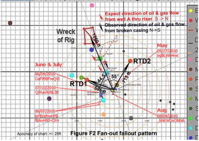
2. Alternatively, if DWH were to be directly above Well A location (within tolerance of a couple % of water depth) then the debris circle should have been centred around Well A location. This is not observed in the debris pattern. If the case is made for the skewed fan-out debris pattern in the direction of the falling riser (towards NW) and DWH wrecks, then the debris fan-out pattern should be as shown in figure F2. As debris fall further away from Well A (source) in the direction of WDH wreck, the angle with respect to the line between Well A and DWH wreck, and the source to the debris should get smaller. Thus, the fallout angle for RTD1 should be larger than that of RTD2. However, the converse is observed. The angle for RTD2 at 55º is greater than the fallout angle for RTD1 at 44.5º. This again proved that DWH could not have been vertically above Well A location.
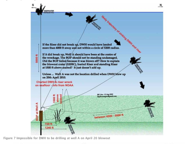
3. The badly twisted and standing riser wreck also proved that DWH could not have been above Well A. It is practically impossible for the riser to be unbroken (as claimed by BP) if the riser had been “anchored” to the BOP attached to Well A. On the other hand, if the lower part of the riser had broken off (contrary to BP’s claims), the pointed “V” wreck pattern should have been radiating from Well A location and not S20BC location. Note that figure 7 was illustrated with the correct aspect ratio (ie the vertical scale is equivalent to the horizontal scale).
4. Further if the broken end of riser resulted in the oil gush at S20BC, there should have been no further leaks beyond S20BC. Clearly this was not the case, as BP reported 3 leaks along the twisted but unbroken 5000ft of riser string. See AlJazeera illustration in figures 7a-7b.

Refer to figures 3a to 3b of Ballastic Analysis of DWH & Riser Wrecks and figure F2.
5. If the riser and BOP were attached to Well A as claimed by BP, then the oil and gas should be gushing out of the riser from the south. But all the video footage clearly showed the oil and gas to be gushing out from the north?
6. If the pipe had been severed at the southern end, how can there still be any flow connection to Well A? It is very clear with the illustrations that oil could not have flowed from the south (Well A) but from a location in the north (S20BC?) which BP was drilling when the well blew up on 20th April 2010.
7. BP’s Gulf Disaster Relief Efforts must have been an elaborate Art of Mass Deception since the 10th of May, 20 days after the 20th April blowout.

Is there a possibility BP actually drilled 3 wells?
Though BP has officially declared having drilled only Well A, there is a possibility that on 6 Feb 2010, DWH drilled Well B instead of reentering Well A which was abandoned on 9 Nov 2009; again without informing MMS. Well B would be just as problematic as Well A, since the same GWSF hazardous condition spans over the three well locations (A, B and S20BC). On the same basis, Relief Well D would be more problematical than Relief Well C which is located at the base of the seabed escarpment. Well A, B, S20BC and Relief Well D are all located within the southern slope face of the escarpment. It is inconsequential whether BP did or did not drill Well B (instead of Well A as officially declared), the fact remains that BP moved to the unreported S20BC location after abandoning the Well A (or Well B as the case may be) in around 17 March 2010. On 20 April 2010, DWH blew at S20BC the unreported mystery location that is still leaking oil and gas into the gulf.

The most important question that begs an immediate answer: Why would BP go through such an elaborate scheme of Mass Deception? They must be pretty sure no one will unravel the truth. There must be more skeletons in the closet.

If you had read my posting on the blowout carefully, the initial gas influx that caused the blowout and fire on DWH was from the extended gas charged pressure (EGCP) zone and not from the bottom of the well as most would have thought. Haliburton would be pleased to know that their bottom cement plug did not fail immediately. There were many technical gaps I had to leave out (for various reasons) until I can find the conclusive evidence. DWH burnt for 2 days fed by gas and oil flowing from the shallow part of the aquifer within the GWSF zone (Why was DWH Blowout so disastrous and beyond patch-up.) This will need more explanation with diagrams in next sequel of Answers to Questions Raised -002.

by BK Lim, Geohazards Specialist (18 August 2010, hydrocomgeo@gmail.com).

Posted in Situation Update | Tagged , , , | Leave a comment

BP Probably Removed The BOP with The Bent Riser and Installed It on Well A Several Weeks After the 20th April Blowout.

14 August 2010, hydrocomgeo@gmail.com

Coincidence is the word we often use when we want to hide the truth. The oil spill disaster has more than its fair share of coincidences. Matt Simmons’s death 4 days ago, is a great loss to all of us seeking the truth. In one of his final interviews, Matt Simmons said, “It was painful as can be… to be the only person in the industry that was willing to speak out.” This article is dedicated to him, all those (animals included) killed and those continuing to suffer from this mega disaster.

Despite BP’s numerous delay tactics, improprieties, inconsistencies and contradictions; the mainstream media, BP’s paid Bogus Press and “Oilmen Expert” bloggers never commented on the obvious flaws in BP’s rendition of the mega disaster. But the same Devil’s Advocates were so quick to bark and maul on articles or postings that disputed BP’s version of events. It was painful indeed to read these biased blogs hammering and mauling Matt Simmons’s character, professionalism and sanity, just because he had disputed BP’s claims and version of events. Many of Matt Simmons’s accounts have since been vindicated by recent whistleblowers’ accounts, evidence of previously undetected oil spill and gas seeps, and health hazards due to extensive usage of Corexit.

BP’s attempts to spin the disaster into an art form through the mass media and paid advertisement are all part of BP’s Charade. The failing Static Kill on the “wrongly” capped well (Macondo A) is just one of the “broken steps”. The return of BP Zombie Well by Fintan Dunne aptly described the multiple failures in trying to kill the wild well. Is there more to it? Did BP drill one or two wells? Apparently the wells were drilled outside their approved period of exploration. Despite what it seems Well B was not drilled at its proposed location. Instead after plugging well A, DWH drilled on an unreported location which blew on 20th April 2010. Were regulations contravened? Continue reading

Posted in Situation Update | Tagged , , , | Leave a comment

Diagrams of the Sinking of the Deepwater Horizon (Macondo Prospect) Proposed by BK Lim

All information below reposted from Phoenix Rising from the Gulf by Dr. Tom Termotto, BCIM

BK Lim has done it again. He presents here an alarming analysis of the events prior to and after the sinking of the Deepwater Horizon on top of the Macondo Prospect in the Gulf of Mexico. We very much appreciate this great revelatory work by BK Lim.

As always, we leave it to our readership to continue to ferret out the real story behind this Crime and Coverup of the Millennium. Our challenge, clearly, is that BP and the US Federal Government have locked down the crime scene known as the Gulf of Mexico with extraordinary police powers. How so? The US appointed BP, a foreign, multi-national corporation, as the lead entity in a unified command structure which was created as the official and legal response to the BP Gulf Oil Spill. Therefore, BP was empowered by our government to effectively enforce martial law in US territorial waters in the wake of BP’s perpetration (with US Federal Government aid and assistance) of an unprecedented series of crimes. Can it get any more bizarre and kafkaesque than this?! We certainly hope not. Continue reading

Posted in Situation Update | Tagged , , , , , , , , , , , , , , | 2 Comments

Why is BP’s Macondo blowout so disastrous & Beyond Patch-up.

Why is BP’s Macondo blowout so disastrous & Beyond Patch-up.

Posted on Newsvine.com Fri Jul 30, 2010 1:10 AM EDT
(25 July 2010, hydrocomgeo@gmail.com).
There has been so much information (or mis-information) on the disaster it is difficult to separate the facts from the myths, let alone decide who is or are to be held responsible for the oil spill disaster. There is a need for a working geological model to integrate all the scattered pieces of information and evidence together, so that law makers can zoom into areas where data had been lacking (or withheld) and the wrongs be corrected in order for the industry to move forward. The fact that so many wells (even in deeper waters) had been drilled successfully in the past in the same Gulf region suggests that there may be more “hidden” factors that caused this blowout to be so disastrous.

The geological model presented here is based on facts derived from past blowout investigations that had been equally puzzling. It provides a fresh perspective into the blowout investigation which until now had been overly focused on the drilling itself. If the well blowout was already a disaster in waiting, there is absolutely nothing the drilling crew could do to prevent the blowout, short of abandoning the well prior to reaching the reservoir. The fact that this geological model had been independently generalized from data and information available on the public domain means that there is room for more detailed infill and ample opportunities for BP’s technical experts to prove the model wrong. On the other hand, if subsequent revelations (from yet to be published data or information) substantiate or improve on the accuracy of the model, then this geological modeling effort, is heading the right direction in providing a more sound basis for corrective measures towards making the oil industry safer from such future disasters. Continue reading

Posted in Situation Update | Tagged , , , , , , , , | 1 Comment

Stay out of the Water! If you CAN’T see the oil then IT IS poisoning you.

Where do people think all the millions upon millions of gallons of oil have gone? Only because the government allowed BP to push it deep into the water column and to break it up into smaller, even more deadly particles with chemicals, doesn’t mean it suddenly vanished.  To the contrary, this process has accelerated its diffusion to the shorelines, and into the air and rain via evaporation cycles, where it will do greater harm to those gullible enough to believe the government, BP, the tourist and real estate industry pundits and media, that “it hasn’t hit us yet” because the sacrosanct tarball of ultimate truth hasn’t been confirmed by a team of experts to have washed up to your shores.
Its VERY important that people understand that BECAUSE you can’t see the oil in the water or on the shoreline it is MORE DANGEROUS than if you can see it, because it has been micronized by a solvent (Corexit 9500) which as a bioaccumulator will accelerate the absorption of deadly hydrocarbons into animal life (that’s us too) exponentionally.  One study published in 2004 showed that Corexit dispersant increased the absorption of hydrocarbons into test fish between 6-1,100 times more readily than the oil alone.   Only because BP has won the PR war by keeping the visible oil off our beaches, this does not mean that what we can’t see isn’t there. In fact, because these particles are so small and combined with a chemical solvent, its guaranteed to do far more harm to our bodies. Please watch the report below to learn more, and consider that according to the EPA’s own toxicological assessment levels of oil in the water as low as 10 ppm are toxic enough to kill 50% of the test fish within 96 hours, while oil mixed with dispersant makes it 3.5 times more toxic at 2.61 ppm to kill 50% of the test fish….
Posted in Situation Update | Tagged , , , , , , | 13 Comments

WAKE UP – BP Will Continue to Use Deadly Dispersants to Cover Up Their Crime Scene If We Do Not Act Now!

S

“In America today you can murder land [insert ocean] for private profit.  You can leave the corpse for all to see, and nobody calls the cops.”  ~Paul Brooks, The Pursuit of Wilderness, 1971

“They [BP] want to hide the body”~ Ian McDonald, FSU oceanographer

Why do Americans think BP is still quoting the ridiculous figure of 5,000 barrels a day, when conservative analysis of satellite imagery indicates that the surface oil alone (10,000+ square miles, May 18th) requires a release rate of at least 26,000 barrels or 109,000 gallons a day?  To cover-up the dagger it shoved into the belly of the Earth, and then through their intentional disregard for safety protocols in the name of profit, turned in a circle to release a leviathan of toxic crude into the world’s oceans.

Immediately following the disaster which killed 11 workers BP claimed there was no leak. As the situation progressed BP and the government ratcheted up the estimates from 1,000 to 5,000 barrels a day, slowly “boiling the frog” of our expectations so the shock would not be so great when the true magnitude of the disaster inevitably came to light.  In the meantime – behind the scenes – the EPA gave BP permission to dump an unprecedented amount of chemical dispersant on and throughout the crime scene, despite the fact that it is so toxic that the UK banned it ten years ago, and the EPA’s own analysis showed it was one of the most toxic and least effective dispersants on the market.

Many BP executives and board members have inside financial ties with Nalco, the manufacturer of BP’s chosen dispersant Corexit 9500, which explains why they plan on dumping another 805,000 gallons of the stuff into the Gulf, as soon as it is available. (TAKE ACTION TO STOP THIS).  What do the dispersants actually do?  Despite outright BP, government and media lies dispersants do not accelerate the biodegradation of the oil, are not safe, and according to the conclusion of a 400-page study published by the National Academy of Science five years ago the decision to use a dispersant boils down to “saving the beach” (can you visit a “clean” beach whose water is toxic and where the air is hazardous to breath?) at the expense of life in the ocean.  BP and the EPA know – because available marine toxicological data proves this – that dispersants accomplish one thing only: they DISPERSE the oil, projecting it deep into  the water column, so that it will not come to surface into the light of public scrutiny.  Like chemotherapy applied to a tumor, it often kills the targeted object AND the patient.  Dispersants, are in fact, up to 4.5 times more toxic to life than the crude oil itself!  Dispersants have been shown to increase the absorption of toxic hydrocarbons up to 15 times more readily in fish than the crude oil itself.  Dispersants and the by-product, dispersed oil, is deadly to coral reefs, which are already threatened with mass extinction due to being smothered by high nutrient run off from the Mississippi, and globally through the increased acidification of the oceans from dissolved carbon dioxide entering at increasingly higher rates from the industry-polluted atmosphere. Once the coral reefs are gone – sometimes called the “rainforests of the sea” – so too will life on land perish. The “mother of all extinctions,” or Perminan extinction, which occured 250 million years ago followed this same sort of etiology.

Thanks to researchers from the University of Southern Mississippi on board the RV Pelican, BP’s government-sanctioned cover-up attempt with the use of dispersants has been revealed.  The team found that deep beneath the iceberg-like tip of the visible surface spill hovers massive oil plumes, including one 10 miles long, 3 miles wide and 300 feet thick. Some of these plumes are at a depth of 2,300-4,200 feet.

“There is a shocking amount of oil in the deep water”, one of the scientists, Samantha Joye, told the New York Times.

BP intentionally used dispersants to keep most of the oil from surfacing. Their present hard-line figure of “5,000 barrels” indicates this motive clearly. They do not want the public to know the extent of the disaster they have created, but by using dispersants they have intentionally accelerated and amplified the murder of an unthinkably vast number of living creatures.

Most people do not understand that 1 gallon of crude oil can pollute approximately 600,000 gallons of sea water. Given the discovery of massive subsurface plumes, the spill may have already released over 100 million gallons of crude (based on the figure of 85,000 barrels a day, or 3.4 million gallons a day released for one month).  If you multiply 100 million times 600,000 you get 60 trillion gallons of seawater rendered toxic to marine life. And the spill is not yet close to being contained. BP’s most recent attempt at placing a catheter into one of the underwater geysers, they claim, will enable them to siphon off the greater part of the “5,000 barrels a day” fantasy they are still shoving down our throats as the truth.  So what are they doing while we sit on the sidelines and pray?

BP plans on dumping close to a million more gallons of chemical dispersant on and around the underwater geyser, to cover up the magnitude of their crime against humanity and all life on this planet.  They have already succeeded in accelerating the dispersion of the oil towards the beaches (oil is slipping under the booms and the surface of the water, while it is still moving into the beaches and marshes) and the loop current, so that the evidence of their crime will eventually bleed into the gulf stream and pollute the world’s oceans at the worst possible time in the ecological history of the planet.  By using this tactic they have guaranteed that marine life in the Gulf will be devastated, and perhaps will never come back.  These crimes are obvious to those with eyes to see.  PLEASE take action against the further use of dispersants by signing our petition, and joining our Facebook group so we can mobilize into action when needed.  We are presently working on finding an organization who will suit to win an injunction against BP’s intention to use more dispersants.

ADDENDUM: THERE ARE NO NON-TOXIC DISPERSANTS

BP’s preferred dispersants, thus far, have been Corexit 9500 and 9527, which are manufactured by Nalco, Inc. BP executives and board members have direct financial ties to Nalco, so that the m0re Corexit they use in their “clean-up” efforts the more they stand to profit from the disaster on the back-end.

This explains why the EPA’s May 20th order for BP to stop using Corexit dispersants within 24 hours, due to their high toxicity and relative ineffectiveness versus other products on the market, was entirely disregarded by the company.  Sadly, this event revealed just how toothless our government’s regulatory agencies are vis-a-vis powerful multinational corporations, and how critical it is that we not rely on our representatives to hold BP accountable. We need a grassroots movement and must demand the end of further dispersant use in the Gulf.

Let’s take a closer look at Corexit. According to the EPA’s dispersant comparison chart Corexit 9500, for instance, has the highest toxicity to Menindia fish of all 18 dispersants tested.  Only 2.61 parts per million of Corexit 9500 (mixed with oil at a ratio of 1:1o) is required to kill 50% of fish exposed to the chemical within 96 hours.  In other words, 1 gallon of the Corexit 9500/oil mixture is capable of rendering 383,141 gallons of water toxic to point of being lethal to 50% of Menindia fish within 96 hours of exposure.

When compared to another EPA approved dispersant, Nokomis 3-F4, Corexit 9500 is 38 times more toxic to Menindia fish and 17 times  more toxic to Mysdopsis “fairy” shrimp.

Corexit 9500 and 9527 were also determined to be the least effective dispersants of all 18 tested, further confirming that BP’s decision to use these products is based on an attempt to profit handsomely from their use, and not their expressed goal of “cleaning up the mess.”

Ultimately the conflict between the EPA and BP being waged right now on using “more effective” and “less toxic” dispersants, skirts the real issues. Although using “less toxic” dispersants is a good idea, the more “effective” they are, the more harm they do to the life in the Gulf.  The focus should not be only on the inherently toxic nature of all dispersants, but on the inherently toxic consequences of dispersing the oil through any means.

Dispersing the oil into the water column accelerates the poisoning of all marine life, deep throughout the water column and seabed. Ultimately it results in “covering-up” the extent of the disaster on the surface, while amplifying the damage within our oceans.  Also, when the dispersants admix with the crude oil, a third far more toxic product is produced called “dispersed oil.”  Dispersed oil has been shown to be more toxic than the sum of its parts.

In the EPA fact sheet on Corexit 9500 the dispersant has a toxicity Menidia beryllina fish of 25.20 parts per million, resulting in the death of 50% of the specimen within 96 hours. The test oil (Fuel Oil #23) exhibited the same toxicity at a lower 10.72 parts per million.  When the Corexit and oil were mixed, however, the EPA tests revealed an exponential increase in the toxicity of the dispersed oil mixture reaching 2.61 parts per million for a lethal dose of 50% of the the fish.

We must see beyond the superficial debate over using “less toxic dispersants” and acknowledge that the dispersion techniques – by their very principle – make the problem far worse.

For Hyper-linked references/articles visit AND to TAKE ACTION visit https://oilspilltruth.wordpress.com author contact sayerji@gmail.com

May 25th Radio interview of Oil Spill Truth blog’s author Sayer Ji :   Radio Interview: \”Exposing BP\’s Cover-Up with Dispersants\”

Posted in Situation Update | Tagged , , , , , , , , , , | 10 Comments

Say NO to the further use of toxic dispersants!

Since the Deepwater Horizon exploded on April 22nd BP has dumped several hundred thousand gallons of chemical dispersant into the Gulf of Mexico. Another 805,000 gallons is on order. The EPA has acted with reckless disregard for the evidence by allowing BP to continue this unsafe and ineffective practice.

Research clearly demonstrates that dispersants are extremely toxic, and that instead of mitigating the damage caused by the oil spill, they amplify the absorption of deadly hydrocarbons into plant and animal life. “Dispersants are also known to remarkably decrease the transfer of oxygen (pdf) into water-based fermentation media This means that in addition to dispersing the oil into large subsurface plumes, the dispersants may well be limiting the ability of water in the Gulf to absorb oxygen from the atmosphere, exacerbating the problem of oxygen depletion caused by the oil itself and by nutrient runoff.”¹

Dispersants also pose an immediate health threat to disaster relief workers and residents in the region, as they adversely affect the air quality by entering wind currents and by accelerating the evaporation of other toxic compounds from the crude oil.

Elected officials must protect the Gulf of Mexico and Americans who make it their home. Tell Congress to halt the use of dangerous dispersants and employ less harmful and more effective methods of disaster mitigation.

Sign the petition to end the use of dispersants in the Gulf.

OTHER ARTICLES ON THE TOPIC

1)  Gulf Oil Spill: Dispersants Have Potential to Cause More Harm Than Good

2) Out of Sign: BP’s dispersants are toxic – but not as toxic as dispersed oil

3) Dispersant ‘may make Deepwater Horizon oil spill more toxic’

4) Chemical dispersants being used in Gulf clean-up are potentially toxic

5) Adding Toxicity to the Gulf: The Exxon-Developed Chemical Being Against the Oil Spill

6) Out of Sight: Dispersed Oil’s High Price

7) Sierra Club: Dispersants Worse than Oil

8)  BP chose more toxic, less effective oil dispersant manufactured by company with ‘close ties’ to oil giant.

9) Less Toxic Dispersants Lose Out in BP Oil Spill Cleanup

10) In Gulf Spill, BP Using Dispersants Banned in U.K.

11) Will Submerged Oil Plume Cause Massive Fish Kills in Gulf?

REFERENCES

¹ Will Submerged Oil Plume Cause Massive Fish Kills in Gulf? by Jim White

Posted in Situation Update | Tagged , , , , , , , , , , , , , | 3 Comments

The Crude Facts…

The environmental catastrophe unfolding in the gulf of Mexico right now is beyond the ability of most of us to fully comprehend.  We who live here must be exceedingly vigilant, as the immediate risks to our health have as much to do with air pollution, as water pollution.  New video footage of the leak indicates that toxic natural gases are being released in tremendous quantities. Indeed, these highly pressurized gases are believed to have played a major role in explosion that lead to the sinking of the Deepwater Horizon oil rig on April 20th.  Initial tests by the EPA on the coastline of Louisana indicated that exceedingly high levels of dangerous “air toxics” were present.

It appears that the “air pollution” aspect of the problem is not being discussed openly, due to the adverse effects it will have on anyone thinking of traveling, investing, or owning real estate here. Indeed, governor Crist is actively courting BP to have them divest millions of dollars to fund a misleading advertising campaign to convince potential visitors that our beaches are safe. Is this really a responsible move if the air itself is liable to become a major health hazard, especially if the highly questionable practice of “controlled burning” continues to be employed? Already areas as far away as Naples have reported complaints by the public of  a “foul smell” and concomitant respiratory symptoms.

At this time we should proceed with the cautionary principle due to the inherent risks of exposure to “air toxics” from the underwater geyser, such as benzene, toluene, ethylbenzenexylene and hydrogen sulfide. These substances can be carried far from their point of origin via air currents, potentially putting residents of our heavily populated coasts at risk. Furthermore, BP’s government-sanctioned disaster mitigation approach thus far has focused on “suppressing symptoms” of the calamity by using highly toxic dispersants to drive the problem deeper into the water column where it will it will do greater harm to wild life, and will accelerate its entry into the gulf stream.

This blog intends to provide a forum for accurate reporting and discussion on the true nature of this catastrophe, with an emphasis on providing information and tools to minimize harmful exposures for those living in the gulf region. We would also like to petition for the end of controlled burning and the use of dispersants.

First in order, is an assessment of the potential of airborne pollutants to cause harm to those in the gulf region. Early figures released by the EPA indicated that levels of toxic pollutants in the air on the coast of Louisana were measured to be up to 100 times higher than considered safe:

EPA Air Testing Data Still Shows High Levels of Airborne Toxins From BP’s DEEPWATER HORIZON Disaster

Statement by Toxicologist Dr. William Sawyer for the Gulf Oil Disaster
Recovery Group representing LEAN and United Commercial Fisherman’s
Association:

“Yesterday, we confirmed a recent evaluation done by the Louisiana
Environmental Action Network (LEAN) of the Environmental Protection Agency’s
results of air content and quality testing, showing that the level of some airborne
toxins is greater than 100 times the quantity considered safe to humans and
could cause physical reactions.

“Mysteriously overnight, EPA withdrew some of these figures and said
they had made an error. However, after EPA reevaluated the data the highest
reading for hydrogen sulfide, which was 1,192 parts per billion on May 3,
remained unchanged. It should also be noted that the levels for volatile organic
compounds were not disputed.

“There is an obvious significant threat not only to the environment and
economy, but also to public health for those downwind of the oil slick. It is
imperative that BP and the federal government immediately release to the public
all information that they have as it effects human health.
“Immediate precautions and continuous monitoring is essential.
“Since weather patterns indicate that sustained winds will blow from the Gulf into
southeast Louisiana over the next few days, action must happen quickly. State
and federal health officials need the ability to act quickly and with accuracy.”
Dr. Sawyer is Chief Toxicologist for Toxicology Consultants & Assessment
Specialists, LLC., Sanibel, FL. As a toxicologist with board certifications in forensic
medicine and forensic examiner, he routinely provides impartial toxicological evaluations involving chemical exposures, alcohol ingestion, intentional poisons involved in homicides, carcinogens, pharmaceuticals, pyrolysis products, heavy metals, organic chemicals and drugs of abuse in civil and criminal litigation.  [Source:  www.gulfoildisasterrecovery.com]

The EPA later recanted these measurements indicating that they were a “mistake.” To view their present assessment you can visit their Air Monitoring on Gulf Coastline Website http://www.epa.gov/bpspill/air.html It is hard to know who to trust in this situation, given the contradictions and just how politically charged this issue is.

The fact remains that gases being emitted by this leak, are known to have serious adverse health effects.

Hydrogen sulfide

Toxicology

Persistence: “The atmospheric residence time of hydrogen
sulfide is typically less than 1 day (Hill, 1973), but may
be as high as 42 days in winter (Bottenheim & Strausz,
1980).” Source

Benzene

Toxicology

Persistence: “Benzene exists in the atmosphere in the gas phase. The dominant atmospheric loss process for benzene in the troposphere is by reaction with the hydroxyl (OH) radical. Based on this reaction, the atmospheric lifetime and half-life are estimated to be 12 days and 8 days, respectively. The reaction products from this reaction include phenol (with a reported yield of 24 percent), glyoxal and other ring-opened compounds (Atkinson, 1994).” Source

Direct inhalation of volatile hydrocarbons

“Direct inhalation of volatile hydrocarbons: Under certain atmospheric conditions, reports have documented adverse health effects in humans from the inhalation of the volatile fraction emanating from large-scale crude oil releases. The volatile hydrocarbon fraction of crude oil contains aromatic hydrocarbons such as toluene, xylenes and benzene at levels from 0.1% to greater than 1%. The potential for such health effects are highly dependent on release quantity and atmospheric conditions (wind, atmospheric inversion) and potentially includes upper respiratory irritation effects, neurological effects and risk to the developing fetus among pregnant females. This is primarily an issue for those living in close proximity to the shoreline and may include large-scale coastal city populations in the event of complete catastrophic failure/release. Emergency management must anticipate this remote possibility.” Dr. William Sawyer, Toxicologist

Ozone

“Ozone hazard: In the event of sustained or catastrophic crude oil releases with specific meteorological conditions present, sufficient volatile hydrocarbons would be present to catalyze the generation of high ozone levels within urban areas such as New Orleans. Ozone is formed in the lower atmosphere regions from the interaction of hydrocarbons and nitrogen dioxide with sunlight. Nitrogen dioxide is already present in urban areas from auto exhaust and other combustion sources. Ozone levels in excess of 40 parts per billion in urban areas are associated with increased morbidity and mortality. Controlled burns would further exacerbate ozone formation.”  Dr. William Sawyer, Toxicologist

Posted in Main Objectives | Tagged , , , , , , | 2 Comments